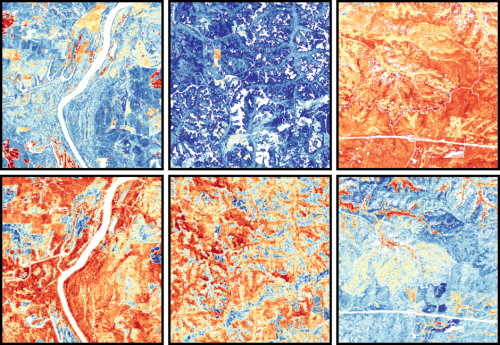
High-resolution satellite images that captured multispectral data recorded the reflections of light from plant leaves. These data are not only of great research importance, providing valuable insights into the physical and biochemical properties of vegetation, but also showcase stunning patterns. Images adapted from Remote Sensing of Environment, 2024, doi.org/10.1016/j.rse.2024.114082.
由衞星衍生的光譜數據,記錄了植物葉片反射光譜的詳細資訊。這些資料不僅具有重要的研究價值,同時展現出美麗的圖案。圖片擷取自《環境遙感》《Remote Sensing of Environment》(2024),doi.org/10.1016/j.rse.2024.114082
Through the Cosmic Lens: Observing Plants from Space’s Eye! Researchers led by Professor Jin WU from HKU School of Biological Sciences have made a breakthrough in mapping plant traits from space using satellite data.
Using time-series satellite data, they have developed an innovative method to map plant traits from space. By analyzing reflections of light from plant leaves and observing plant life cycles, they have gained valuable insights into ecosystem functioning and resilience. This innovative approach has the potential to enhance our understanding of climate change impacts and ecosystem health.
The journal paper, entitled ‘Spectra-phenology integration for high-resolution, accurate, and scalable mapping of foliar functional traits using time-series Sentinel-2 data’, can be found at the following link: https://doi.org/10.1016/j.rse.2024.114082
港大生物科學學院吳錦教授領導的研究團隊,成功運用衞星以太空視角觀測陸地植物葉片反射光譜的詳細資訊,以了解陸地植物的內在物理和生化特性,為研究氣候變遷提供了強大的技術支援。