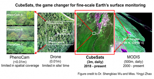
Our Earth has experienced rapid environmental changes tightly tied to anthropogenic activities. Satellite remote sensing offers a quantitative means to monitoring such changes but is often limited to coarser spatial or temporal resolutions. Only very recently, the arrival of CubeSats with daily and global coverage at a 3-m resolution offers an unprecedented opportunity for fine-scale Earth’s surface monitoring.
However, several outstanding issues remain with the CubeSat observations that further hinder its broader applications: 1) CubeSat observations source from over 190 satellite sensors with varying sun angles, causing the data inconsistency issue across different sensors, 2) frequent clouds and cloud shadows often contaminate the satellite signal, and 3) the accurate biophysical interpretation of satellite signal remains lacking. To address the first issue, we developed a rigorous method to cross-calibrate CubeSats using a more stable single-sensor satellite—Moderate Resolution Imaging Spectroradiometer (MODIS) as the reference. To address the second issue, we developed a novel cloud/shadow screening method which leveraged the spatial and temporal information of satellite reflectance bands to enable automatic and accurate cloud and shadow screening. To address the third issue, we developed a spectral unmixing approach that effectively classified the forest canopy into leafy vs. leafless phenophases, from which it would enable fine-scale accurate phenology monitoring of tropical forests. Similarly, by integrating proximate drone survey data (with crown-scale tree segmentation) with CubeSat observations, we for-the-first-time demonstrated the feasibility to monitor plant phenology at the individual tree-crown scale. The relevant results have been respectively published in Remote Sensing of Environment (RSE; 2020, 2021), and ISPRS Journal of Photogrammetry and Remote Sensing (ISPRS, 2021). It is worthy to note that RSE and ISPRS are the two best journals in the remote sensing field, with the impact factor of 10.16 and 8.98, respectively.
“Our researches have made significant technical advances to make full use of these new-generation satellite data, and ultimately facilitate the monitoring of Earth’s environmental changes, especially for those rapid and fine-scale changes”, says Dr. Jing Wang, the leading author of the two RSE papers. “There have been a series of papers in RSE either relying on tower-mounted phenocams or frequent drone flights to monitor tree-crown scale leaf phenology or relying on satellites to monitor ecosystem scale but not at the tree-crown scale. Our work is not another one, but a new attempt to explore the possibility and spatial resolution limit to enable satellite techniques for tree-crown scale leaf phenology monitoring, which thus represents the cutting-edge research frontier and also opens a world of possibilities for individual-based ecology studies using satellite techniques.” says Dr. Jin Wu, PI of Global Ecology and Remote Sensing (GEARS) Lab at the University of Hong Kong.
With these advances, in the next step, the GEARS lab is aiming to leverage CubeSats and other geospatial technologies to facilitate the research in relevant fields, which include but are not limited to ecological scaling principles, biodiversity research, forest growth, health, and management practices, climate change impact assessments and mitigation strategies, and ultimately the nature-based solutions to reaching carbon neutral goals.
These journal papers can be accessed from here, here, and here:
For more information about Dr. Jin WU’s research, please visit here.