
 |
|
|
|
|
Miscellany
 The
Bass that ate Biwa (or Protecting Japan's Largest Lake)
The
Bass that ate Biwa (or Protecting Japan's Largest Lake)
![]() Notes
on the ecological value of Sham Wat Stream and its valley
Notes
on the ecological value of Sham Wat Stream and its valley
![]() What
is a 'Conservation Area' and what does it conserve?
What
is a 'Conservation Area' and what does it conserve?
![]()
The Bass that ate Biwa (or Protecting Japan's Largest Lake)
by David Dudgeon
In the spirit of Richard Corletts travelogue in the last issue of Porcupine!, I would like to share some observations made during a recent trip to Japan. I was a guest of the Shiga Prefectural Government (a part of Japan near Kyoto, Nara and Osaka). Although the Prefecture is landlocked, there is plenty of aquatic habitat in the form of Lake Biwa Japans largest lake. It has a maximum depth of over 100 m and an area of 674 km2; in other words, it covers more than half the total extent of Hong Kong SAR. The catchment is around 3,200 km2, and occupies over 90% of Shiga Prefecture. The boundaries match the Prefectural borders almost exactly. This feature has important implications that I will come back to later. Lake Biwa was designated a Ramsar site in 1993. It is an important sanctuary for migratory birds and supports Japans largest freshwater fishery. Of greater significance is its age: 4 million years. This puts it in the same category as other ancient lakes such as Lake Tanganyika, Lake Baikal, and the Caspian Sea. Like those lakes, Biwa hosts an array of endemic species. Although it lacks something as emblematic as the freshwater seals of Lake Baikal, Lake Biwa supports 57 species and subspecies (the taxonomic rank of some of them is difficult to determine) found nowhere else. They include 12 species of fish, 38 benthic invertebrates (mainly molluscs), and two aquatic macrophytes.
Approximately 1.3 million people live along the shores of Lake Biwa, and over 20% of them are clustered around the shallow southern basin (which averages only 4 m in depth). Inevitably, then, there are problems with contamination (!jargon alert!), and the primaeval oligotrophic lake is now distinctly mesotrophic tending to eutrophic in the southern basin. Pollution from domestic, industrial and agricultural sources have caused problems such as red tides (Uroglena americana seems to have been the culprit), blooms of blue-green algae (Anabena and Microcystis), and choking growths of exotic waterweeds (Elodea and Egeria). These problems first appeared in the late 1970s. The Shiga Prefectural Government was aware of the likely environmental consequences of a large, rapidly growing population situated within an enclosed lake basin. In 1973, they introduced pollution control ordinances that were more stringent than those applied nationally and, in 1979, strengthened these by introducing specific new clauses directed towards reductions in nitrogen and phosphate in effluents. The laws were beefed up again in 1996. Infrastructural investment in sewage treatment has been impressive, and the few houses that are not connected to a treatment plant are visited periodically whereupon the accumulated human excrement is vacuumed out and taken to a municipal treatment works. (I didnt actually see this myself, but this is the kind of thing that Im willing to take on trust!) Other initiatives included low-interest loans with long repayment periods that could allow small-scale industries to upgrade waste-treatment facilities and, in 1985, a ban on the sale of detergents containing phosphorus. Agricultural pollution sources have been tackled by legislation that restricts the use of certain fertilizers.
None of these measures would have been successful without the support of the local people. Fortunately, the inhabitants of Shiga Prefecture are proud of Lake Biwa, and are committed to protecting it. The many local citizens groups organize neighbourhood and shoreline clean ups, environmental fairs and other community activities. In addition, environmental education is a mandatory and important part of school curricula, there are numerous local education centres, and all 5th grade primary school students are taken on an overnight field-trip cum cruise on Lake Biwa in the Prefectural school boat (really!). The Lake Biwa Museum, opened in 1996, played host to its three millionth visitor around the time that I was there. This figure indicates the extent of local interest and pride in the Lake. It is certainly an excellent museum, focussing on the Lake and its biota (there is an excellent aquarium), the human uses of the Lake and its cultural significance, as well as the conservation significance of ancient lakes in a global context.
I got the strong impression from the people I met that they took great pride in the efforts made to protect Lake Biwa and its biota. Nevertheless, it must be said that there is some enlightened self-interest at work here. Lake Biwa provides drinking water for 14 million people (including cities such as Kyoto). So it is not too surprising that the Prefectural Government has set stringent water-quality standards for the Lake. Yet despite strenuous efforts, the water quality in the Lake does not yet meet the targets set. However, those targets are stringent, and the current condition of the Lake is not far off the desired standard. Plus the Prefectural Government has a well-staffed and committed Department of Environmental Policy (something that Hong Kong lacks), and all of the major stakeholders seem dedicated to the goal of protecting Lake Biwa. That objective seems realisable because the Prefectural boundaries match the limits of the drainage basin almost precisely this allows the possibility of local government control of all activities with the potential to damage the Lake environment. To put things in the context prevailing in most Asian countries where the policy on the environment (such as it is) is usually something along the lines of develop now clean up later, Shiga Prefecture definitely seems to be at the later stage.
So, is this one of those near mythic beasts - an environmental success story? I thought so at first. A closer look uncovers a rather different story for example, the loss of almost the entire reed-bed habitat along the shoreline to rice farming, and the introduction of large amounts of fine sediments from waters draining agricultural land. That said, it might be that the main threat faced by the biota of Lake Biwa is invasion by exotic species. The plants and animals in this ancient Lake have evolved in isolation, and the community is vulnerable to invasion by species from elsewhere. I have already mentioned exotic aquatic plants, but the main category of invaders is freshwater fish. Predators from North America such as Black (= Large-mouth) bass (Micropterus salmoides) and Bluegill sunfish (Lepomis macrochirus) have been introduced (perhaps by anglers) and are busy eating their way through the native fish fauna. At least one Asian species of Snakehead (Channa argus), a highly efficient predator upon frogs and fishes, is present also, as is an exotic goby that appears to occupy the same niche as the endemic Lake Biwa goby. It seems likely that the European bitterling ( Rhodeus sericeus ) will soon become established who knows what effect this will have on the five species of indigenous bitterlings in Lake Biwa.
I do not mean to give the impression that no one is aware of the threats posed by exotic species. Scientists are concerned and, behind the scenes in the Lake Biwa Museum, captive breeding of endemic fishes is being undertaken. Ex situ conservation seems a viable - albeit depressing option for some species. Many other individuals, although lacking paper credentials, are worried about the fate of Lake Biwa also. I met a couple of elderly gentlemen belonging to a citizens environmental group who were trying to teach farmers about the difference between exotic Mosquitofish (Gambusia affinis) and the native Ricefish (Oryzias latipes) upon which it preys. (There is an eerie parallel here with the interaction between Mosquitofish and Oryzias curvinotus in Hong Kong.) One of their aims was to persuade farmers to engineer the environment of paddy fields along the Lake shores so as to maintain favourable conditions for Ricefish. But how to engineer the entire Lake in order to safeguard indigenous and endemic fishes from an array of predators against which they have evolved no defenses? That is one question that Japanese ingenuity and commitment to environmental protection has yet to answer. Unfortunately, time is running out.
| P.15-16 |
![]()
A Road to Nowhere
by Lisa Hopkinson
the Green Lantau Association
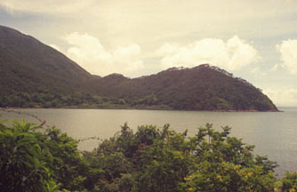
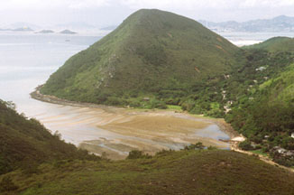
In 1995, the-then Director of Audit criticised a $25 million highway from Sham Wat, a picturesque little bay south of the airport (between Tai O and Tung Chung), to Sha Lo Wan. The Highways Department had already completed Stage 1, involving a $11 million 2.2 km road to Sham Wat, from the road leading to Ngong Ping, in 1990. Stage 2 involved extending the road further up the coast to Sha Lo Wan.
The District Office had somehow estimated that the road would serve 600 villagers but the census actually showed only 73 people living there. The Director of Audit rightly decided that it would be a gross waste of public money to spend a further $25 million on 73 people, and blamed poor planning of the Highways Department and the Home Affairs Department. One of the original reasons for the road, was that it was thought that the public pier at Sha Lo Wan may be removed due to the airport works, but in the end it was retained. The government suspended Stage 2. Or did it?
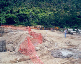
Five years later Highways Department are back, and guess what, theyve started building a road from Sham Wat to Sha Lo Wan. What was once a beautiful little beach is now a construction site. The Sham Wat stream, which is estimated to be one of the most ecologically diverse in Lantau, has been crudely diverted. Construction waste has been dumped on mangroves and mudflats and the contractor has extended his works area well beyond what is legally and contractually permitted.
The road, with armour rock wall and crash barriers, stops after about 50 metres, and thus gives vehicular access to a handful of villagers that previously had to walk across a footbridge to get to their cars. The new construction is grossly and irrevocably inappropriate and intrusive and a gross overdesign for a one-in-a-hundred years typhoon. The armour rock wall protects a 4 metre reinforced concrete wall, the whole replacing a gently shelving beach of seagrass.
The once peaceful village of Sham Wat was featured in a coastal walk between Tung Chung and Tai O in Friends of the Earths Lantau Coastal Guide:
"It would be worth planning your walk to arrive here for a picnic lunch as it is a beautiful location. A refreshing dip in the beautiful stream is also highly recommended."
Now the village is full of construction vehicles, noise and dust.
Highways Department stated in a letter to the Green Lantau Association (GLA) in July 2000 that the contractor would be excluded from areas outside the site boundary, that Highways Departments site staff would monitor the contractor and that the contractor would be instructed to erect a fence around the site boundary to limit disturbances to ecological resources in the area.
The GLA has held two site visits with the Highways Departments consultant Resident Engineer, Mouchel Asia Ltd, and contractor, Hang Kee Construction Ltd in September and November 2000. Agreements reached at these site meetings have largely not been honoured. The GLA thus decided that under the present circumstances further site visits would not be fruitful. GLA has since asked the Lands Department to consider prosecuting the consultants and contractor for trespass onto government land. GLA is also preparing a submission to the Director of Audit and the Ombudsman.
The so-called Resident Engineer is actually resident engineer for two other projects in Sai Kung, severely limiting the amount of time he can spend at Sham Wat. Highways Department failed to turn up at both site meetings and even while fully aware of the various breaches of contract have continued to reassure GLA in writing that "precautionary and mitigation measures required as a result of the ecological review will be implemented".
Many of these problems could have been avoided had there been an environmental assessment conducted for this project. However, since this is considered a minor rural project, it is excluded from the EIA process, and therefore lacks an effective enforcement mechanism. Instead, government officials witnessing illegal occupation and destruction of government land do nothing but write warning letters which they know will be ignored.
If this was an isolated case it wouldnt be so bad, but similar minor acts of destruction are going on all the time, promoted by villagers, aided and abetted by government works departments and funded by tax-payers. Completely unnecessary concreting of streams, footpaths and slopes - some of them so over the top as to become absurd. One footpath on Lamma has so much concrete that even the rocks adjacent to the path have their own concrete plinths.
The Home Affairs Department which administers the Rural Public Works ( RPW ) Programme (formerly known as the Rural Planning & Improvement Strategy Minor Works Programme (RPIS), guaranteed to strike dread into the heart of environmentalists ) has a budget of $100 million for the financial year 2000/01. While this is small beer in government terms, it translates into a lot of damage to the SARs streams, beaches and woodlands. The HAD circulates details of the projects to the Environmental Protection Department and Agriculture, Fisheries & Conservation Department, who generally have no objection. The projects are approved by District Councillors and District Officers, who generally have an interest in encouraging employment for local contractors.
What is needed is for EPD to bring these projects within the EIA purview . While small projects, due to the ecological sensitivity of the project locations, they can actually do a lot of damage, both individually and cumulatively. A full EIA would not be necessary in most cases, but could focus on ecological and visual impacts only in many cases. Perhaps a panel comprising representatives from EPD and AFCD could be formed to deal with works under a certain cost ceiling.
The Director of Audit should also take a close look at the need for many of these projects with the current system of term contractors there appears to be an awful lot of work being generated for works sake. Last, but not least, government engineers within Home Affairs Department, and government works departments need a crash course in ecology.
 |
 |
 |
 |
| P.16-17 |
![]()
Notes on the ecological value of Sham Wat Stream and its valley
by Bosco Chan and Michael Lau
Sham Wat, or Sai Tso Wan in North Lantau retains its rural characteristics due to its inaccessibility; visitors have to walk either from Tai O or Tung Chung along the coast, or take the steep walk starting around Ngong Ping. Despite having most of the stream flow intercepted by a catchwater at about 100 m above sea level, Sham Wat Stream has copious year-round flow and a diverse and natural physical environment. Fish life was both diverse and abundant prior to recent channelization and construction work; a total of 15 fish species were recorded by BC in his PhD study, one of the highest fish species richnesses for local streams , and, in particular, it has many migratory species. A goby species previously unrecorded in Hong Kong freshwaters, Redigobius cf. bikolanus was found, and other interesting records included the carp Nicholsicypris normalis and two rarely seen sleepers, Eleotris acanthopoma and E. melanosoma. Nicholsicypris normalis was thought to be restricted to the eastern side of the mainland New Territories, but it occurred in good numbers in Sham Wat Stream. In Hong Kong, both E. acanthopoma and E. melanosoma have only been recorded in streams on Lantau. Sham Wat was also the only stream during BCs study where three species of sleepers co-existed in pure freshwater. The high abundance of these predatory species also suggests that a very productive ecosystem existed in Sham Wat Stream. In addition, the locally rare dragonfly Diplacodes nebulosa and locally uncommon Three-striped Grass Frog Rana macrodactyla were found along the grassy banks during the Biodiversity Survey.
Prior to the present destruction, the strip of mangrove which lined the estuary and the gentle gradient/flow of the lowland section provided ample food sources and allowed penetration of migratory fishes, respectively. Sadly, the river mouth was recently destroyed to accommodate the new road, and the lower section of the stream, which had the most interesting fish fauna, was dredged and all pools and riparian vegetation were destroyed. Nutrient input is likely to be lower after destruction of the mangrove and the riparian vegetation, and the dredged channel has noticeably faster water flow. These alterations are likely to affect the structure of the fish community, since species preferring pool or slow current habitats are unlikely to cope with the changes.
Although this short note discusses some of the ecological value of the valley and highlights the need to conduct baseline ecological assessment for "minor" government works, the information provided here is by no means comprehensive and more species of conservation value could surely be found with more intensive field work. The lack of a comprehensive ecological survey is a common phenomenon for many remote inlets (e.g. those facing Crooked Harbour and Double Haven), basins (e.g. those excised within Country Parks), and foothills (e.g. those scattered in the Kam Tin/Yuen Long and Sha Tau Kok areas), where vehicular access is impossible and "outsiders" are not always welcomed by the villagers.
Naturally, scientists tend to concentrate their efforts in sites with either easy access ( e.g. Tai Po Kau ) or with known interest (e.g. Tai Ho). Hence many hidden ecological hotspots face the danger of quietly disappearing as a result of the Governments well-intentioned but often environmentally-destructive "improvement" projects.
| P.17-18 |
![]()
More on Grid References
by Jackie Yip Yin
In an earlier issue of Porcupine! George Walthew warned us of the use of grid references from old (pre-1994) topographic maps, because the geodetic datum has been changed from the Hong Kong 1980 Geodetic Datum (HK80 Datum) to the World Geodetic System (WGS84 Datum). The problem does not end there. The topographic maps offer three different methods to mark the location of a site, so which method should we use? A couple of puzzled fellow postgrads have asked me this question.
The 1:20000 topographic maps (HM20C Series) published by the Survey and Mapping Office present three types of coordinate systems:
1. latitude and longitude
2. Universal Transverse Mercator Grid (UTM Grid)
3. Hong Kong 1980 Grid (HK1980 Grid)
To put it simply, if you are planning to publish in international journals, use either 1 or 2, because these are global systems. These can also be read directly in the field by Global Positioning System ( GPS ) receivers. HK1980 Grid is only used locally, but it has the benefit of being equally sized. The HK1980 Grid is used by the Biodiversity Survey.
The coordinate systems should not be confused with the geodetic datum. HK80 and WGS84 are both geodetic datums, which are ellipsoids defined with orientation, position, size and shape, as references for positions. UTM and HK1980 Grids are coordinate systems. Coordinate systems are based on map projections, which are the representation of the latitude and longitude of the ellipsoidal Earth surface on a flat surface. Imagine the UTM projection as a cylinder wrapping the Earth, the UTM grid system is obtained by slitting the cylinder and flattening it on a map. Because the HK80 and the WGS84 Datums give different reference positions, a change of geodetic datum yields different latitudes and longitude as well as UTM coordinates, as discussed in Walthews article. However, this is not completely hopeless because you can tell which geodetic datum is used by looking at the prefixes. The UTM zones in Hong Kong using HK80 Datum are Zones 49Q GQ, HQ and Zones 50Q JV, KV. These have been changed to Zones 49Q GE, HE and Zones 50Q JK and KK respectively under WGS84 Datum, with slight shifting of grid lines. Therefore, while you can leave out the Grid Zones 49Q and 50Q in the grid references, you should always state whether it is from GE, HE, JK or KK.
The above is relevant only if you are using the Topographic Maps (e.g. HM20C Series). Life is a lot easier if you use the Countryside Series Maps, because they have only UTM Grid coordinates. The UTM coordinates can be written in either way, with alphabetical prefixes (GE, HE, JK and KK), or numeral prefixes (7, 8, 1, 2 respectively), but the Survey and Mapping Office has created an extra source of confusion by leaving out the alphabetical prefixes in the Countryside Series Maps. A location read as 50Q KK10 65 in the Topographic Maps can also be read as 210000 E, 2465000 N if you are using the Countryside Series, but the former is the global reference. If you have not bought any maps, my advice is to get the Topographic Maps. They show topographic features more clearly, they offer more choices of grid references, and they cost just about the same.
Bibliography
Survey and Mapping Office (1995) Explanatory Notes on Geodetic Datums in Hong Kong. Survey and Mapping Office, Lands Department.
Walthew, G. (1997). Whats in a grid reference? Porcupine! 15: 56.
| P.18 |
![]()
Shui Hau - Past and Present
By David Y. N. Poon and Benny K. K. Chan
Prologue
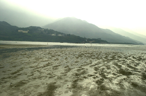
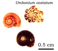
Shui Hau, one of the few sheltered sand flats in Hong Kong, is located on the south coast of Lantau Island. Morton and Morton (1983) have given a detailed description of the fauna and flora there, and refer to it as an undisturbed soft shore having a rich faunal diversity, with the bivalve Meretrix (Fig. 1) and the tiny gastropod Umbonium (Fig. 1) being the dominant species (a Meretrix Umbonium sand flat).
 |
|
 |
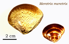 |
| Fig.1 A sand flat at Shui Hau showing the abundant species recorded in the past. Both Umbonium and Meretrix are polymorphic and their shell colour are variable. | |
Ecological studies conducted in Shui Hau, however, have received relatively scant attention. This is possibly due to its remoteness in comparison to other soft shores (e.g. Starfish Bay, where a number of surveys have been done during the local marine workshops; also see Lee, 1996 ). Also, with increasing pollution and human disturbance, much of our local marine fauna and fauna is now in peril (Morton et al., 1996). In early November, we visited Shui Hau twice during spring low tides and there seem to have been changes in faunal composition in comparison with that described by Morton and Morton (1983), almost two decades ago. This article therefore aims at providing a qualitative ecological description of Shui Hau, based on what we observed during these trips. We also hope, through addressing the possible faunal changes and some special observations, that this article can provide some baseline information for future potential ecological studies on Shui Hau and the sand flats elsewhere in Hong Kong.
The Sand Flat Fauna
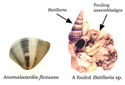
The upper shore of the sand flat consisted of a large number of burrows, which were most probably dug by the ghost crabs (Ocypode sp.). As we moved down the upper shore, smaller burrows, with sand balls radiating from the entrance (a characteristic feature of sand bubbler crabs, Scopimera spp.), were more common,. Further down the shore the epifauna was dominated by hermit crabs ( Clibanarius, Diogenes, and Pagurus ) and potamidid snails ( Batillaria spp. ) , with Nassarius festivus also seen crawling around on the low shore. There was a considerable number of Batillaria with shells heavily fouled by sessile epibionts (e.g. the barnacles Balanus reticulatus, and the oysters Saccostrea cucullata, which are roughly double the weight of the snails shell (Fig. 2)). The same phenomenon was also observed on Batillaria shells occupied by hermit crabs. On soft shores, hard substratum is a limiting resource for many sessile/sedentary marine invertebrates (Olabarria, 2000 ). Fouled snails can suffer from increased drag that may in turn retard growth (Wahl, 1996; 1997) and fouled mussels are more susceptible to predation (Wahl et al. 1997). Also, provided that there is a cost, in terms of energy expenditure, involved in carrying a shell (Herreid and Full, 1986), hermit crabs should prefer non-fouled shells to the fouled ones, as reported by Conover (1978) and McClintock (1985). Shell availability can limit the population of hermit crabs (Kellogg, 1976; Vance, 1972). At Shui Hau, does the observed high number of hermit crabs hosting fouled Batillaria shells, support the shell-limitation hypothesis; or do they have a preference for fouled shells because of some intrinsic benefits (Olabarria, 2000; Wahl, 1989)? Also, given the detrimental effects that fouling could have on marine gastropods, does fouling of Batillaria (probably decreasing the life span) indirectly help provide a new supply of empty shells to the hermit crabs?
 |
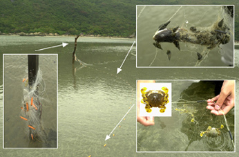 |
| Fig.2. The abundant organisms (the bivalve Anomalocardia flexuosa and the fouled Batillaria sp.) at Shui Hau during the visits in November 2000. | Fig.3. A line of Fishing net found across the sand flat at Shui Hau which resulted in a crab disaster 'for details, refer to text'. |
We also searched for the infauna along the tidal gradient. What we found, however, was not a handful of Meretrix and Umbonium, but a considerable number of Anomalocardia flexuosa (Fig. 2), with live Meretrix occasionally recovered from the substratum. Umbonium were present, but were not as abundant as described in Morton and Morton (1983). In addition, all the Umbonium found were empty shells, suggesting that the molluscan diversity of Shui Hau may have declined. There were also a lot of tubes (built by polychaetes) protruding from the sandy substratum (Fig. 3).
Fishes, Crabs, and Disaster!
 |
There were a number of wooden piles erected at regular intervals on the intertidal region of the sand flats, and the presence of a trammel-net gave a clue to their function. With curiosity we examined the nets. During our first visit to Shui Hau, along the net we saw dozens of fish carrion, including the marine catfish Plotosus lineatus (see inset of Fig. 4), and these carrion attracted clusters of Batillaria snails Wait! Potamidids are not carnivores! They were in fact hermit crabs, comprising at least three different species (Clibanarius infraspinatus, C. longitarsus and Diogenes spinifrons). In only a few clusters could we find the small scavenging gastropod Nassarius festivus, but they were not abundant, which is contrary to the observations made at Starfish Bay during the Environmental Biology Field Course, and those reported in the literature (e.g. Britton and Morton, 1992; Morton and Yuen, 2000). |
| Fig. 4. The U-shaped burrow of a polychaete during out from the sand flat. |
As well as fish carrion, common sand crabs Matuta lunaris were also seen "resting" in the proximity of the net (Fig. 4), which is very unusual as they are often wary of the presence of humans. On closer examination the mystery was solved they were entangled by the trammel-nets. Here, what shocked us most was that, on lifting up the net a "chain" of Matuta was found entangled near the base (Fig. 4)! We managed to save some by cutting the net but finally gave up, as the number of trapped crabs was enormous (And sad to say, on our second visit a week later, most of the crabs were found dead in the net, and this time many Nassarius festivus were found under the net and nearby). Although the artisanal fishery created a food source for the hermit crabs and the nassariid snails, it caused a catastrophe to the population of M. lunaris. A similar crab disaster was also observed in Three Fathoms Cove during the 1999 Environmental Biology Field Course.
The Boulder Fringe
After examining the trammel-net we accessed the high shore again and reached a small boulder field lining the border of the shore. Here, many boulders were heavily colonized by the rock oyster Saccostrea cucullata and the barnacles Balanus reticulatus and B. albicostatus. Upon approaching the boulders the grapsid Metopograpsus messor were seen running about swiftly. The area was scattered with litter, which further indicates that Shui Hau is no more an unspoiled sand flat.
Mangrove Stand and Grass Field
Not far from the boulder fringe there was a small stream, with gobiid fishes (most probably mud skippers) jumping around as we were wading through the water. After crossing the stream, there was a small mangrove stand with Avicennia marina and Aegiceras corniculatum being the common species (see species list below), some of them entangled by plastic litter. Unlike other local mangrove stands, sesarmine crabs were scarce. As we moved further there was a small grass field. At first glance there was nothing special but again, on closer examination, the ground was full of burrows and the sesarmine Parasesarma erythrodactylum was abundant and juveniles were seen running about quickly.
Epilogue
Based on what we could see throughout the trip, it is obvious that the once unspoiled sand flat has received considerable human disturbance. Although our survey was largely qualitative in nature, environmental degradation could well be the cause for the observed decline in abundance of Meretrix and Umbonium, as well as many other molluscan species recorded in Morton and Morton (1983). In addition, human exploitation may also lead to the decline in abundance of Meretrix (collection of Meretrix by local fishermen in Shui Hau was also reported by Morton and Morton (1983) and the price of Meretrix sold in a Japanese supermarket at Causeway Bay nowadays is roughly $78 for 15 individuals). In Hong Kong studies of intertidal ecology have largely been focused on the hard shores and mangroves. Most of the studies concerning the sandy shore organisms were focused on molluscs, in particular the nassariid snails ( Britton and Morton, 1992; Chan, 1998; Cheung, 1997; Cheung and Lam, 1999; Morton and Yuen, 2000). Very little is known about the ecology of many other local soft shore communities. Apart from the effects of pollution and human disturbance, there still exists a high diversity of crustacean and molluscan fauna ( especially Starfish Bay, pers. obs. ), of which the ecology is still little understood. It is, therefore, a time to initiate more research in soft shores.
Acknowledgements
We would like to thank Dr. His-Te Shih (National Sun Yat-sen University, Kaohsiung, Taiwan) and Timothy Lam for their help on identification of hermit crabs and fishes respectively.
Bibliography
Britton, J.C., and Morton, B. (1992). The ecology and feeding behaviour of Nassarius festivus (Prosobranchia: Nassariidae) from two Hong Kong Bays. In: The Marine Fauna and Flora of Hong Kong and Southern China, Hong Kong 1989. Hong Kong University Press, Hong Kong, pp. 395-416.
Chan, K. (1998). The development of Nassarius festivus (Powys 1835) (Gastropoda: Nassariidae) in Hong Kong. In: Morton B. (ed) The Marine Biology of the South China Sea. Proceedings of the 3rd International Conference on the Marine Biology of the South China Sea. Hong Kong University Press, Hong Kong, pp. 321-330.
Cheung, S.G. ( 1997 ). Physiological and behavioural responses of the intertidal scavenging gastropod Nassarius festivus to salinity changes. Mar. Biol. 129: 301-307.
Cheung, S. G., and Lam, S. ( 1999 ). Effect of food availability on egg production and packaging in the intertidal scavenging gastropod Nassarius festivus. Mar. Biol. 135, 281-287.
Conover, M.R. (1978). The importance of various shell characteristics to the shell-selection behaviour of hermit crabs. J. Exp. Mar. Biol. Ecol. 32: 131-142.
Herreid, C. F., and Full, R. J. (1986) . Energetics of hermit crabs during locomotion: the cost of carrying a shell. J. Exp. Biol. 120: 297-308.
Kellogg, C.W. (1976). Gastropod shells: a potential limiting resource for hermit crabs. J. Exp. Mar. Biol. Ecol. 22: 101-111.
Lee, S. Y. ( 1996 ). Distribution pattern and interaction of two infaunal bivalves, Tapes philippinarum (Adams and Reeve) and Anomalocardia squamosa (Linnaeus) (Bivalvia: Veneridae). J. Exp. Mar. Biol. Ecol. 201: 253-273.
McClintock, T.S. (1985). Effects of shell condition and size upon the shell choice behaviour of hermit crab. J. Exp. Mar. Biol. Ecol. 88: 271-285.
Miyake, S. (1982). Japanese Crustacean Decapods and Stomatopods in Color Vol. I: Macrura, Anomura and Stomatopoda. Hoikusha Publishing, Japan. (Japanese text)
Miyake, S. (1983). Japanese Crustacean Decapods and Stomatopods in Color Vol. II: Brachyura (Crabs). Hoikusha Publishing, Japan. (Japanese text)
Morton, B., and Morton, J. (1983). The Sea Shore Ecology of Hong Kong. Hong Kong University Press, Hong Kong. 350 pp.
Morton, B., and Yuen, W.Y. (2000). The feeding behaviour and competition for carrion between two sympatric scavengers on a sandy shore in Hong Kong: the gastropod, Nassarius festivus (Powys) and the hermit crab, Diogenes edwardsii (De Haan). J. Exp. Mar. Biol. Ecol. 246: 1-29.
Morton, B., Williams, G. A., and Lee, S. Y. ( 1996 ). The benthic marine ecology of Hong Kong: a dwindling heritage? In: Coastal Infrastructure Development in Hong Kong: A Review. Hong Kong Government, Hong Kong, pp. 233-267.
Olabarria, C. (2000). Epibiont molluscs on neogastropod shells from sandy bottoms, Pacific coast of Mexico. J. Mar. Biol. Ass. U.K. 80: 291-298.
Vance, R.R. (1972). Competition and mechanism of coexistence in three sympatric species of intertidal hermit crabs. Ecology 53: 1063-1074.
Wahl, M. (1989). Marine epibiosis. I. Fouling and antifouling: some basic aspects. Mar. Ecol. Prog. Ser. 58: 175-189.
Wahl, M. (1996). Fouled snails in flow: potential of epibionts on Littorina littorea to increase drag and reduce snail growth rates. Mar. Ecol. Prog. Ser. 138: 157-168.
Wahl, M. (1997). Increased drag reduces growth of snails: comparison of flume and in situ experiments. Mar. Ecol. Prog. Ser. 151: 291-293.
Wahl, M., Hay, M.E., and Enderlein, P. (1997). Effects of epibiosis on consumer-prey interactions. Hydrobiologia 355: 49-59.
List of organisms found during the Shui Hau visits (* = abundant)
|
BIVALVIA |
CIRRIPEDIA |
| Anomalocardia flexuosa* |
Balanus reticulatus* |
| Anomalocardia squamosa | Balanus albicostatus* |
| Dosinia sinensis | Balanus amphitritev |
| Meretrix meretrix | |
| Saccostrea cucullata* |
| DECAPODA | |
| Anomura | Brachyura |
| Clibanarius infraspinatus | Gaetice depressus |
| Clibanarius longitarsus* | Matuta lunaris |
| Diogenes spinifrons* | Metopograpsus messor |
| Pagurus dubius | Ocypode sp. |
| Parasesarma erythrodactylum* |
| GASTROPODA | MANGROVE PLANTS |
| Batillaria multiformis*. | Avicennia marina* |
| Clithon spp*. | Aegiceras corniculatum* |
| Nassarius festivus | Kandelia candel |
| Polinices ??? | Acanthus ilicifolius |
| Lumnitzera racemosa |
| P.19-21 |
![]()
What is a 'Conservation Area' and what does it conserve?
by Richard T. Corlett
Hong Kong's protected area legislation is far more complex than one would expect for such a small place. Taking the broadest possible definition of 'protected area' an area where biodiversity receives some form of protection - Hong Kong has: Country Parks, Special Areas, Marine Parks, Marine Reserves, Restricted Areas (sometimes called Wild Animal Protection Areas), Sites of Special Scientific Interest (SSSIs), Conservation Areas, Coastal Protection Areas and Green Belts all of which have some degree of legal backing plus a number of non-statutory designations, including Landscape Protection Area (in Metroplan), Wetland Conservation Area and Wetland Buffer Area. Furthermore, the government has a variety of powers to protect wildlife outside these areas, some of which apply to the whole of Hong Kong (such as the Wild Animals Protection Ordinance), some of which apply only to Government Land (the Forest and Countryside Ordinance), and some of which apply only to specific types of leased land (such as those with lease clauses which prohibit tree felling without permission).
The most confusing of these categories is Conservation Area (CA), because of inconsistencies between the name, the way in which the government sometimes uses this category, and the legal protection it confers. Conservation Areas derive their legal authority from the Town Planning Ordinance, under which the planning intentions of the government are translated into statutory Outline Zoning Plans (OZPs). Areas covered by these plans are assigned various land-use zonings, such as Agriculture, Recreation, Village Type Development, SSSI, Conservation Area, Coastal Protection Area, and Green Belt. The non-statutory Hong Kong Planning Standards and Guidelines refers to the last four of these land - use zonings as " conservation zones " ( note the small "c"! ), but gives "to conserve and protect flora and fauna" as the planning intention only for SSSIs. Conservation Areas are intended "to retain existing natural features and rural use", Coastal Protection Areas "to retain natural coastline" and Green Belts "to define the limits of urban development areas by conserving landscape features".
Planning notes attached to every OZP list, in a "Schedule of Uses" for each land-use zoning, the "uses always permitted" (also known as "Column 1" uses) and the "uses that may be permitted with or without conditions on application to the Town Planning Board " (" Column 2" uses). There is also usually an " Explanatory Statement ", which goes into more details on the planning intention of each area but is not, legally, part of the plan. Although, in theory, the schedule of uses for each zoning category can vary between different plans, in practice, they are more or less standardized. For SSSIs, there are usually no uses which are always permitted, so such a designation gives strong protection against adverse land-use changes. For Conservation Areas, in contrast, the "always permitted" uses usually include at least "agricultural use" and "tree plantation". No doubt these are seen as fully compatible with the intention "to retain existing natural features and rural use".
Unfortunately, however, Conservation Area has also become an alternative zoning for areas of high conservation value for which SSSI status, although appropriate, was opposed by villagers or other local interests. Thus in the Luk Keng and Wo Hang OZP, both the abandoned Yim Tso Ha Egretry and the current egretry on A Chau are given SSSI status, but the diverse and important freshwater marsh at Luk Keng, and the large, old and diverse fung shui wood at Sheung Wo Hang, are designated as Conservation Areas. Clearly, neither agriculture nor tree planting are compatible land uses in these cases, although they are still listed in Column 1 of the Schedule. The planning intentions of the Luk Keng and Sheung Wo Hang Conservation Areas are made very clear in the explanatory statement, which refers to them both as "sites of ecological importance "which should" be protected and preserved". However, no permission is needed for land-use changes which are in the "always permitted" column, so the planning intention in such cases is never consulted and becomes, in effect, irrelevant.
Does this mean that that any ecologically valuable site which is designated as a Conservation Area can be destroyed by conversion to agriculture or a plantation? The answer to this question will depend on whether the site is on Government or leased land and, if leased, the type of lease conditions, if any. Most village-associated habitats, like fung shui woods and freshwater wetlands, are likely to be on old leases without any conditions that restrict cultivation. In such cases, genuine protection rather than simply "flagging" the site as important requires that all incompatible land-use changes need permission. Although this could easily be achieved in a Conservation Area by simply removing incompatible uses from the "always permitted" column, it would make a lot more sense to designate all such sites as SSSIs.
Unfortunately, there are also problems with SSSI status. It is only a land-use zoning and provides no protection from adverse impacts (such as collecting plants or trapping animals) which do not involve a change in land use. In the long term, it would make even more sense to include these areas within the adjacent Pat Sin Leng Country Park. Indeed, the same applies to many other small areas of high conservation value that have been designated as Conservation Areas or SSSIs, and are immediately adjacent to the boundaries of Country Parks.
Outline Zoning Plans can be obtained from the Lands Department map sales counters on the 23rd floor of the North Point Government Offices in Java Road or the ground floor at 382 Nathan Road. Information on the availability and status of OZPs and other statutory plans is available on the Planning Departments excellent web site (www.info.gov.hk/planning). This site also has the full text of the Hong Kong Planning Standards and Guidelines, as well as both the Town Planning Ordinance and the draft Town Planning Bill which is intended to replace it.
| P.22 |
![]()
Greedy Hong Kong Shock!
by David Dudgeon
The UNEP World Conservation Monitoring Centre, World Wide Fund for Nature and their collaborators have just published the Living Planet Report 2000. Much of that report deals with ecological footprints. These measure a populations consumption of food, materials and energy in terms of the area of biologically-productive land or sea required to produce those resources and absorb the corresponding waste. The ecological footprint method therefore allows us to estimate the human pressures on the earth, and compare humanitys demands on nature with the Earths capacity to supply resources and assimilate wastes. The basic message of this report is that the ecological footprint of the global population is over 30% larger than the Earths biological productive capacity. That is bad news. What is worse, is the way that Hong Kong features in global rankings of countries according to their ecological footprint. We rank 13th overall out of a total of 150 nations, but this is in terms of our total ecological footprint. If we look at individual components of the footprint, we rank 8th in terms of the cropland footprint (i.e. the area required to produce all the crops that an individual consumes); 6th in terms of forest footprint (the area needed to produce the fuelwood, paper and timber that we use); 11th in terms of fishing ground footprint (the area required to produce the fish and seafood products we eat); and, 8th in terms of our carbon dioxide footprint ( the area required to absorb emissions resulting from our energy consumption).
A sobering perspective on these data can be obtained by comparing the ecological footprint of Hong Kong with our own domestic biological capacity. The difference between the footprint and this capacity represents our ecological deficit. That value for Hong Kong is 67.07 the highest of any population on Earth. For comparison, UAR which is ranked second scores 15.3, USA scores 6.66, Taiwan 4.14, mainland China 0.96, and New Zealand 6.26. While these data do not necessarily indicate which nations are on the path to sustainability, and which are not, they do indicate the challenges ahead if we are to preserve global ecosystems through this century and beyond.
Bibliography
Loh, J. (Ed), 2000. Living Planet Report 2000. World Wide fund for Nature, Gland, Switzerland. 32 pp.
| P.23 |
|
Porcupine! |
 Copyright © 2000 |